
CHARLOTTE, N.C. — The winter season is upon us, and it already feels brisk and cold in the Carolinas this year. For the nineteenth straight year, WCNC Charlotte Chief Meteorologist Brad Panovich presents his annual storm fall predictions in his annual Winter Weather Outlook for Charlotte and the western Carolinas.
These are the factors that will influence snowfall in the Carolinas this year:
La Niña:
For the third consecutive year, we will be influenced heavily by La Niña. This is pretty rare to see three straight years with La Niña influencing the seasonal outlook.
As a refresher, La Niña is when we have cooler than average water in the Pacific Ocean near the Equator. This causes a shift to the jetstream over North America, which causes the ingredients of our weather patterns.
In an average LaNiña winter, Charlotte sees warmer and drier weather compared with what is typically considered average winter temperatures and precipitation. While we usually see less snow in these setups, exclusions apply. That's what happened earlier in 2022: When January saw snowy weather three weeks in a row. By the end of the 2021-2022 winter season, Charlotte only got slightly more snow than the city's 3.5" average.
With such a small average, one snow event can easily put the Carolinas over-the-top of average.

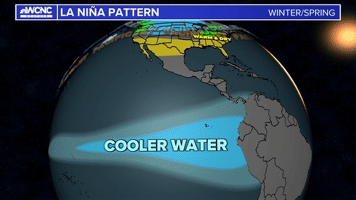
There are other factors I look at besides La Niña; its opposite phase, called El Niña, or middle ground, is considered a neutral phase.
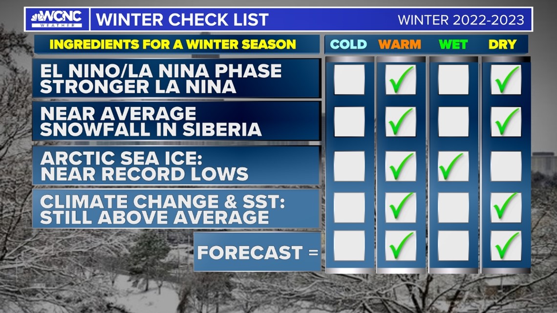
Here is a look at the checklist I was when crafting Charlotte's snow forecast. Those factors include the state of the Arctic sea ice and the amount of snowfall in Siberia.

Climate change:
So why is our average snowfall so low? Climate change has really affected our snowfall.
Just a decade ago our 30-year average, at the time stretching back to the 1980s, was 4.4” of snowfall per year. Now with the average including recent years of breaking or near-record-breaking temperatures, Charlotte's snowfall average has fallen to 3.5” per year.
In general, Charlotte's winter season is slowly getting milder and we are seeing less snow. This doesn’t mean we are seeing no snow, but what is far more common is more extremes of little-to-no snow for years than a year with an excessive amount.
We have lost the consistency of winter snowfall.
Another impact of a warmer climate is the decreasing arctic sea ice, which causes a more erratic polar jetstream. This change brings wild weather swings, including record warmth, severe weather, and short-lived arctic blasts.
Brad's Charlotte snowfall forecast:
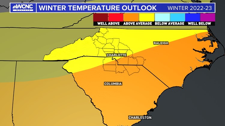
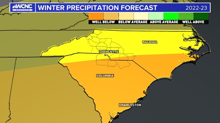
So with La Niña fully in effect again, it is hard to argue against a warmer and drier winter compared to the average. However, overall I would expect we will end up slightly above average for temperatures and below average for precipitation. Here's why:
The drought
The drought that started this summer will continue into the winter with less rainfall than normal expected.
Brad's Winter Forecast


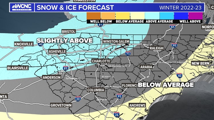

Snow & Ice:
Last year even though we ended up with warmer and drier conditions overall, we still managed to get an above-average snowfall seasonal total.
Active storm tracks in the Ohio Valley can sometimes briefly slide south. This track change occurs when the North Atlantic Oscillation (NAO) and Artic Oscillation (AO) go negative and cause a change in the sea-level pressure difference. As seen in January 2022, these shifts can last a week or more and create colder air and enhance storm tracks into the Carolinas.
Like last winter, and a few La Niña winters in the past, we could have three weeks of warm and dry weather followed by a week of cold and wet atmospheric conditions. While the 3-month average will be warm and dry overall, we can still get enough snow and ice to be considered "above average" by the conclusion of the winter season.
RELATED: No, it does not hurt your engine if you don't warm it up all the way before driving in cold weather
Some bold predictions:
Like last year, I like to throw out some bold predictions for specific locations across topography in the western Carolinas: Charlotte for the Piedmont, Hickory for the foothills, and Boone for the mountains.
These exact amounts are, frankly, likely to be wrong. It's really impossible to forecast a specific total months in advance. These numbers are a representation of what I generally expect:
Charlotte: 5.1", above the average of 3.5"
Hickory: 7.6", above the average of 6.9"
Boone: 33.1", above the average of 25.6"

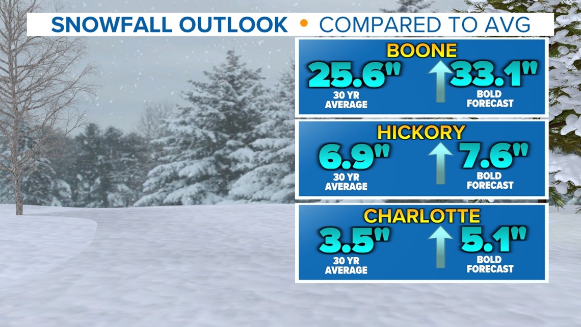
When it comes to verifying these numbers, the National Weather Service takes official snowfall observations at Charlotte Douglas International Airport, the Hickory Regional Airport, and the Watauga County Hospital Helipad in Boone.
Have questions?
Contact Brad Panovich at bpanovich@wcnc.com or follow him on Facebook, Twitter and Instagram.