
CHARLOTTE, N.C. -- Now that the precipitation has moved through, the First Warn Storm Team is warning that the most hazardous conditions still lie ahead.
A Winter Weather Advisory is in effect until noon Sunday for the entire viewing area due to the likelihood of black ice. All of the wet spots are beginning to ice, especially on the secondary roads.
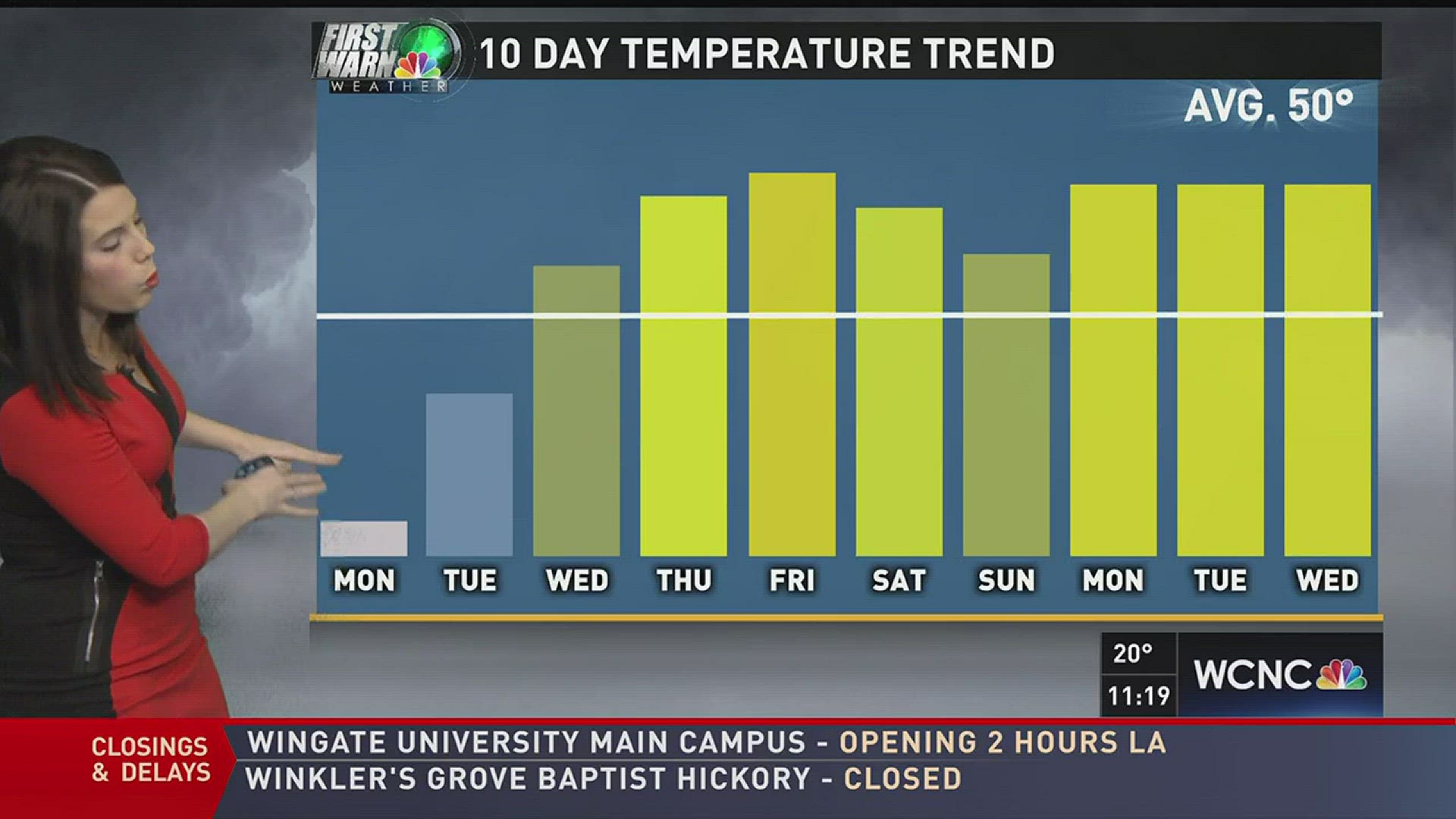
Freezing temperatures cause concern for melting snow to turn to ice. John Wendel says that until Tuesday morning, temperatures are expected to stay at or below freezing.
The First Warn Storm Team is monitoring the threat of black ice, as refreezing is a potential as people go back to work and students head back to school.
As of Sunday afternoon, temperatures remained below freezing. A wind chill caused already cold temperatures to feel even chillier.
Wind chill BRRRRR!!! pic.twitter.com/gH2H8yIUXc
— John Wendel wcnc (@johnwcnc) January 8, 2017
"I can't emphasize enough just how cold this air mass is on the backside," said Chief Meteorologist Brad Panovich.
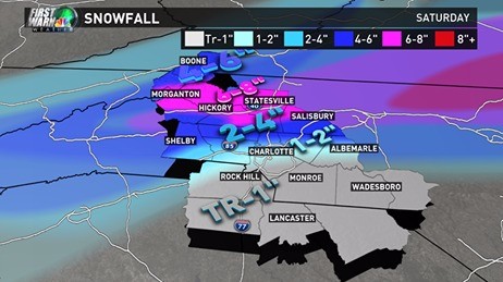
A mix of rain, sleet, and snow fell across the Charlotte area overnight as part of a winter storm that dumped as much as 10 inches of snow in the Carolinas.
According to the National Weather Service, the heaviest snow fell in Polk County, where Saluda received 10.1 inches. A little closer to Charlotte, portions of Burke County received over seven inches of snow.
In the Charlotte area, Mother Nature delivered a wide variety of weather, with some parts north and west of the city seeing as much as seven inches of snow, while some areas south and east of Charlotte saw mostly freezing rain and sleet. In Huntersville, the National Weather Service indicated over four inches of snowfall as the high point in Mecklenburg County.
Due to warmer temperatures lingering, areas south and east of I-85 received mostly sleet that hindered snowfall accumulation. Some flurries moved through the viewing area Saturday morning as the majority of the precipitation moved out.
Governor Roy Cooper and officials with the NC State Highway Patrol announced that troopers had responded to over 200 crashes between midnight at 6 a.m. Saturday. Cooper urged all residents to stay home as long as icy conditions are prevalent on the roads, as roadways will be treacherous in the early morning and late evening hours.
All 100 of North Carolina's counties, along with South Carolina, are under a State of Emergency.
Latest forecast: http://on.wcnc.com/2j0wI2e
Winter Storm: 5 things you need to know
Download the WCNC app for winter weather alerts: http://on.wcnc.com/2hXHwQU
Need to submit a closing? Here's what you need to know