
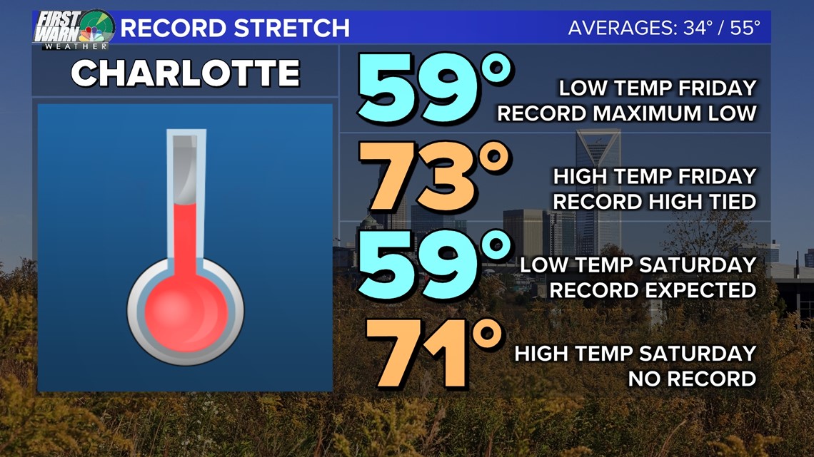
CHARLOTTE, N.C. — It seems like a story we’ve written before, right? A record high temperature of 75 degrees is forecast at Charlotte Douglas International Airport Friday.
Just before 3 p.m., Charlotte Douglas recorded a temperature of 73 degrees, tying the record set in 1956.
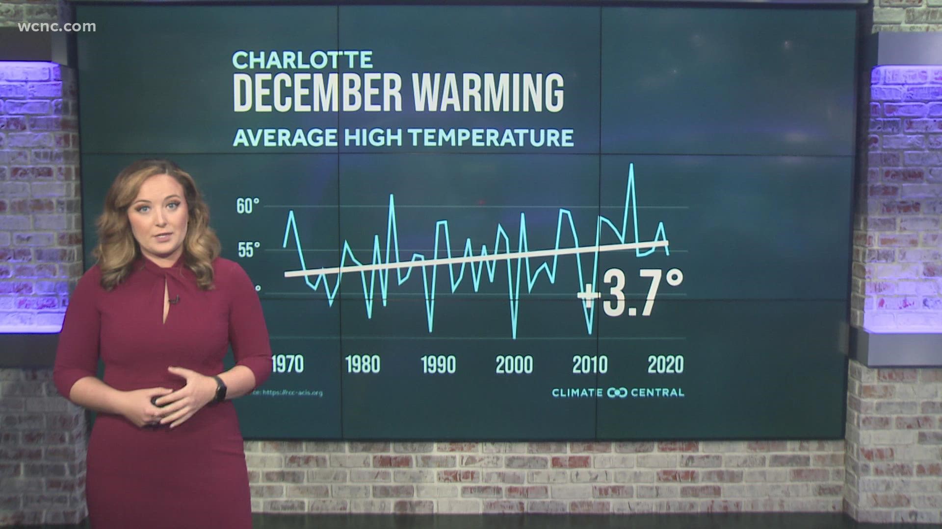
This is the sixth day in December we’ve had highs in the 70s (and Saturday will make seven!) Our average high this time of year is 55, so we’re close to 20 degrees warmer than normal.
This is also the second record high recorded this month. Back on Dec. 3, we shattered the record of 75 degrees, reaching 78.
Additionally, Friday morning also broke the record for the warmest low temperature. That previous record was 55 in 2015, but we only dropped to 59 degrees due to cloud cover and high moisture content. And guess what? It could happen again Saturday morning.

Why are we so warm? Well, in the short term, a front is situated just to our north with high pressure on either side. This clockwise rotation is pumping warm, tropical air into the Carolinas from the southwest. Chief Meteorologist Brad Panovich often refers to the southwesterly wind as a “blowtorch” for our local weather.
This trend of warm weather can be tied directly to the La Niña pattern we’ve seen developing throughout the year. In the United States, La Niña is associated with warm temperatures from the Southwest to the Southeast, and cold temperatures in the upper Midwest, and expanding to the Pacific Northwest.
It’s also associated with drier conditions in the South and wetter conditions in the Midwest and Pacific Northwest. Why? It all has to do with the jetstream.
During La Niña, trade winds are even stronger than usual, pushing more warm water toward Asia. Off the west coast of North and South America, upwelling increases, bringing cold water to the surface of the Pacific Ocean.

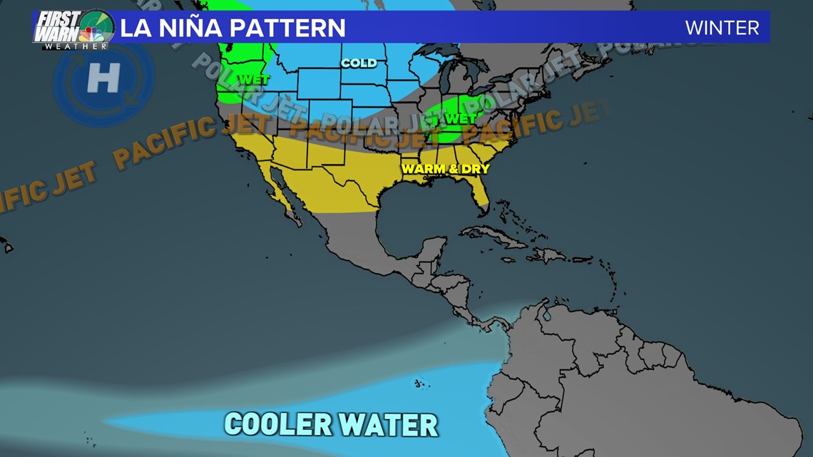
These cold waters in the Pacific push the jet stream northward. With a storm track further north, locally we have fewer storms that develop, which drives the rain toward the Midwest and Pacific Northwest.
What’s interesting with the pattern over the past week – which led to multiple deadly severe weather events across the country – was how high the jet stream was. It was even further north than usual, which prompted tornado warnings over an area that had snow on the ground.
This is important because it shows the overall pattern of warmer than normal conditions – you need warm, moist air, spin and lift to spawn tornadoes. How often does this happen in an area cold enough for snow on the ground? Rarely, if ever.
Why do we experience La Niña?
During normal conditions in the Pacific ocean, trade winds blow west along the equator, taking warm water from South America towards Asia. To replace that warm water, cold water from deep in the ocean gets pulled to the surface by the wind – which is referred to as upwelling.
El Niño and La Niña are two opposing climate patterns that break these normal conditions. These events typically last nine to 12 months, but can sometimes last for years. They don’t occur on a regular schedule, and generally, El Niño occurs more frequently than La Niña.
Remember: these are climate patterns based on a 30-year average. Weather is different than climate because it refers to what we see daily. Weather is what you get, climate is what you expect. So, while La Niña doesn’t mean we’ll be warm every day of winter, it’s a climate pattern that we can watch, observe, and help us be prepared for what’s to come.
Contact Brittany Van Voorhees at bvanvoorhe@wcnc.com and follow her on Facebook, Twitter and Instagram.