
CHARLOTTE, N.C. — Snowfall has been a luxury in Charlotte over the past decade. Even rainfall lately has been hard to find. The Queen City ended last year almost 8 inches drier than normal and under a severe drought for the first time since 2015.
You need precipitation and moisture to have snow. But you need other things, too, like persistent cold air, and that air has to be cold enough at all levels of the atmosphere. Think of the atmosphere as a birthday cake – the air needs to be cold enough in the highest levels so that water vapor that may normally condense into cloud droplets turns to ice first instead of liquid water.

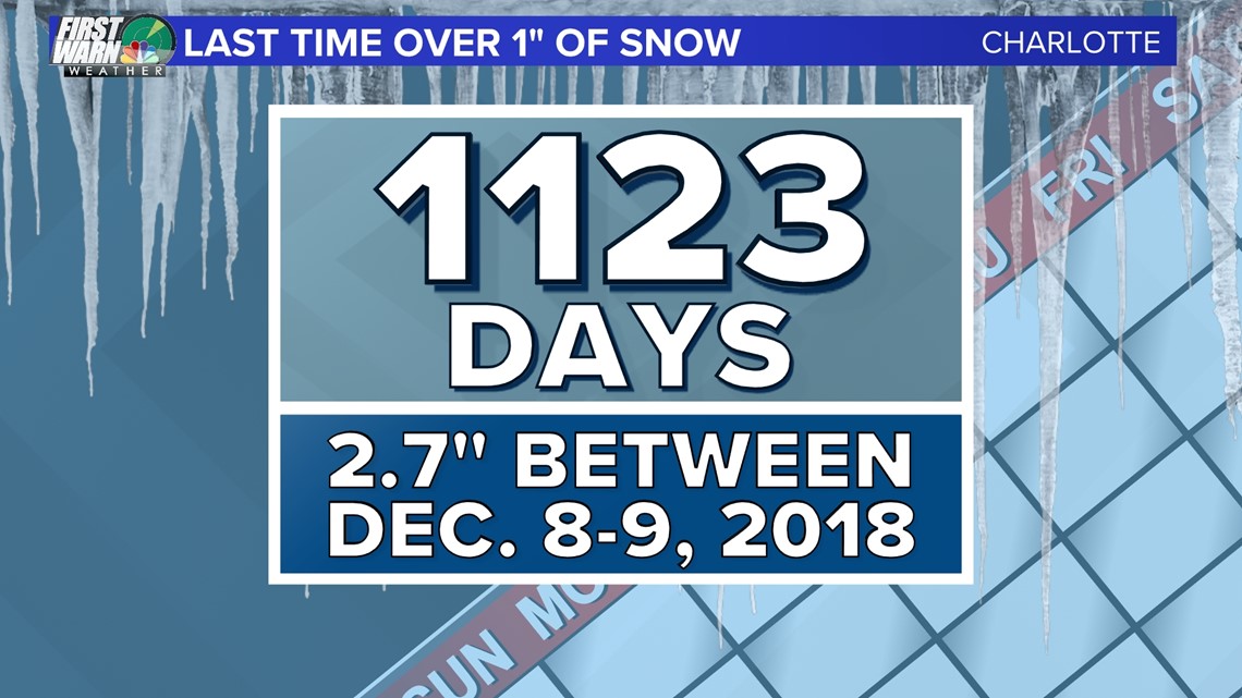
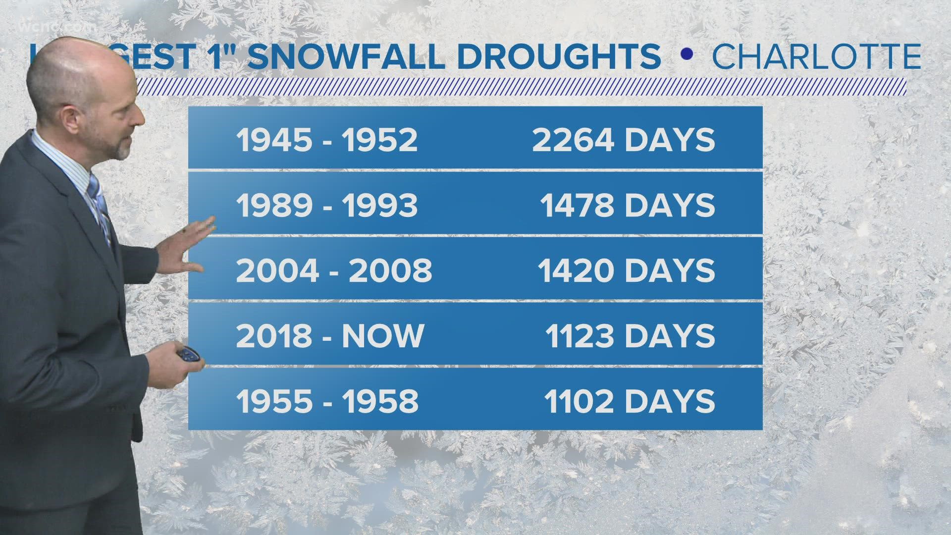
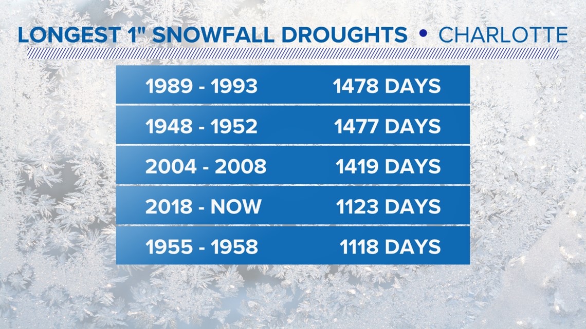
It’s been 1,123 days since we saw one inch of snowfall in Charlotte. Back in December of 2018, 2.7 inches fell between the 8th and the 9th. Since then, there has been measurable snowfall in the Queen City – but not of that magnitude.
In fact, we’ve measured less than once inch total in that three-year plus span, when we should normally receive around 10.5 inches. That’s less than 10% of where we should “normally” be snowfall-wise.
Although our snowfall drought is a far cry from the record of 1,478 days (no more than 1” of snow was measured between Feb. 24, 1989, through Mar. 12, 1993) - it has recently broken the top four. And with our climate continuing to warm, the ability to break out of these droughts may become more difficult.

New climate data from 1990 through 2020 saw Charlotte’s average snowfall drop to 3.5” per year. However, in the last 10 years, the average has been closer to 2.6 inches. With the warmer and drier than average winter expected due to La Niña, this is unlikely to change anytime soon.
If you’re a snow lover itching to see some action, another round of wintry precipitation is expected in the mountains and foothills Thursday night and Friday morning. Most of the foothills could see a trace to an inch, southern portions of the mountains 1-2 inches, and upwards of 2-4 for most of Ashe, Watauga, and Avery counties. The highest elevations could peak around 6 inches, but that’ll be the exception, not the rule.
Contact Brittany Van Voorhees at bvanvoorhe@wcnc.com and follow her on Facebook, Twitter and Instagram.