COLUMBIA, S.C. — Tropical Depression Claudette is bringing severe weather and flash flooding to the Midlands of South Carolina.
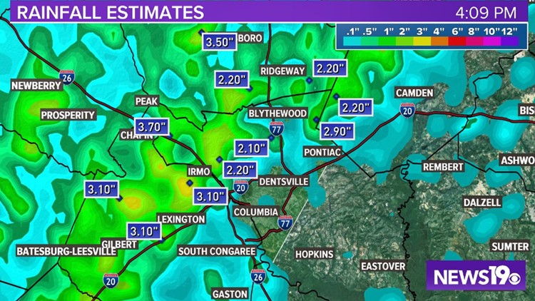
A flash flood warning is in effect for Calhoun, Fairfield, Kershaw, Newberry, Lexington, and Richland Counties until 7:15 p.m. By late Sunday afternoon, several areas in the Midlands had received 2 to 3 inches of rain already, with more on the way.
People should stay off the roads if possible, but if they do drive, don't attempt to cross a road that's covered in water.
The tornado warning that was in effect for western Lexington County has now expired. The possible tornado was indicated on radar. At present, it's unclear if a twister was actually on the ground.
While that warning may be over, more could be coming, as Claudette continues to stir up the atmosphere as it pushes into South Carolina. Here's the latest on the forecast for the tropical system.
Current Conditions
Claudette is still a tropical depression. The storm was located about 80 miles west of Columbia. Claudette was moving east-northeast at 17 mph. It had sustained winds of 30 mph with some stronger gusts.
The storm is still not very symmetrical. Most of the rain and storms are on the eastern side of the system, well away from the center of circulation.
Forecast
A flash flood watch is in effect for most of South Carolina. The watch continues through early Monday morning.
Considerable flash, urban and small stream flooding is possible as heavy rainfall moves across the state.
The system is moving east-northeast. It should gradually accelerate in that direction through tonight as it moves ahead of a digging trough over the central United States.
All of the models show the system near the North Carolina coast by midday Monday. Conditions appear to be right for the redevelopment of Claudette once it encounters a more unstable marine environment late today.
A tropical storm warning is now in effect for most of the coast of North Carolina. A tropical storm watch is in effect for the Grand Strand region of South Carolina.
Local Impacts:
Given the current forecast, significant rainfall is expected to move into the area and severe thunderstorms will be possible too.

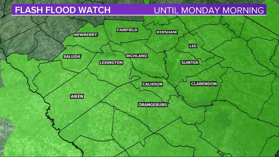
The chance will increase for heavy rainfall through Sunday night. Localized flash flooding will be possible. The flash flood watch for the Midlands continues through Monday morning.

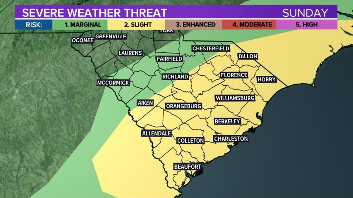
Severe thunderstorms are for the rest of the day. The greatest threat is damaging wind gusts, but isolated tornadoes are possible. This is very typical of landfalling tropical systems.
The higher risk for severe weather is in the eastern and southern parts of the Midlands. That area is under a slight risk for severe weather. The rest of the Midlands is under a marginal risk, according to the Storm Prediction Center.
There are currently no severe weather watches or warnings in effect for the Midlands.
Timing of Claudette in SC:
Late Sunday PM and very Early Monday

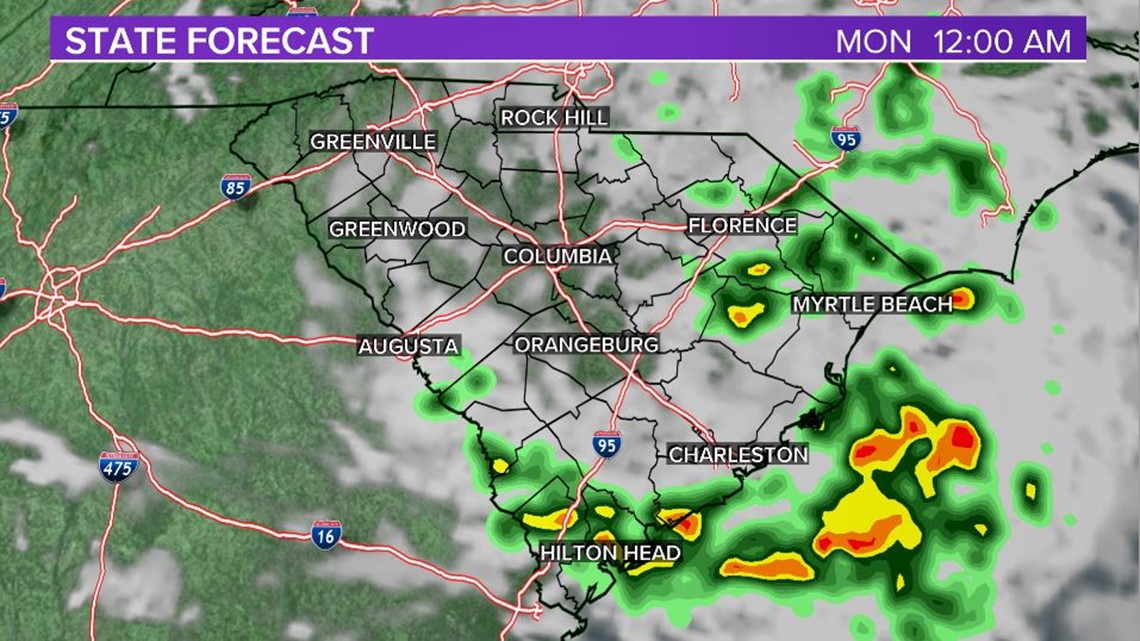
The chance for rain will move out. The threat of severe weather will diminish as the tropical depression moves out of the region.