
CHARLOTTE, N.C. — Winter in the Carolinas is right around the corner, which means it is time for First Warn Storm Team Chief Meteorologist Brad Panovich's 17th annual winter forecast.
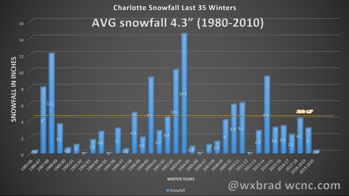
Even though Charlotte averages just 4.3 inches of snow per winter, in the 142 years of record-keeping Charlotte has never had a season with zero snowfall. So while many times the Queen City has had less than an inch or just a trace, we always seem to get something at some point between December and March.
PAST 35 YEARS
The trends have been bad for snow lovers, which admittedly, I am. Charlotte has been getting fewer winters with above-average snowfall for a while now. In the past 20 years, Charlotte has seen above-average snowfall just six times. That's only about 30% of the years since the new millennium.

FACTORS FOR THE SEASON
La Niña
The phase of El Nino or La Niña might be the most significant winter season indicator for most of the U.S. The developing La Nina, which has already impacted our current hurricane season, will also be around for the upcoming winter season. La Niña is a cooling of the water in the Equatorial Pacific Ocean. This below-average water temperature affects the jet stream over the U.S. during the winter season. It usually means warm and dry for our winters. Though diving into those numbers further shows that when La Niña is weak or moderate and not a strong one, we tend to have a better chance for above-average snowfall. Overall, though, we don't do well in La Niña winters for snow lovers.
Average Siberian Autumn snowfall:
This year snowfall in Siberia was near average, which doesn’t make much difference on cold or snow versus warm and dry.
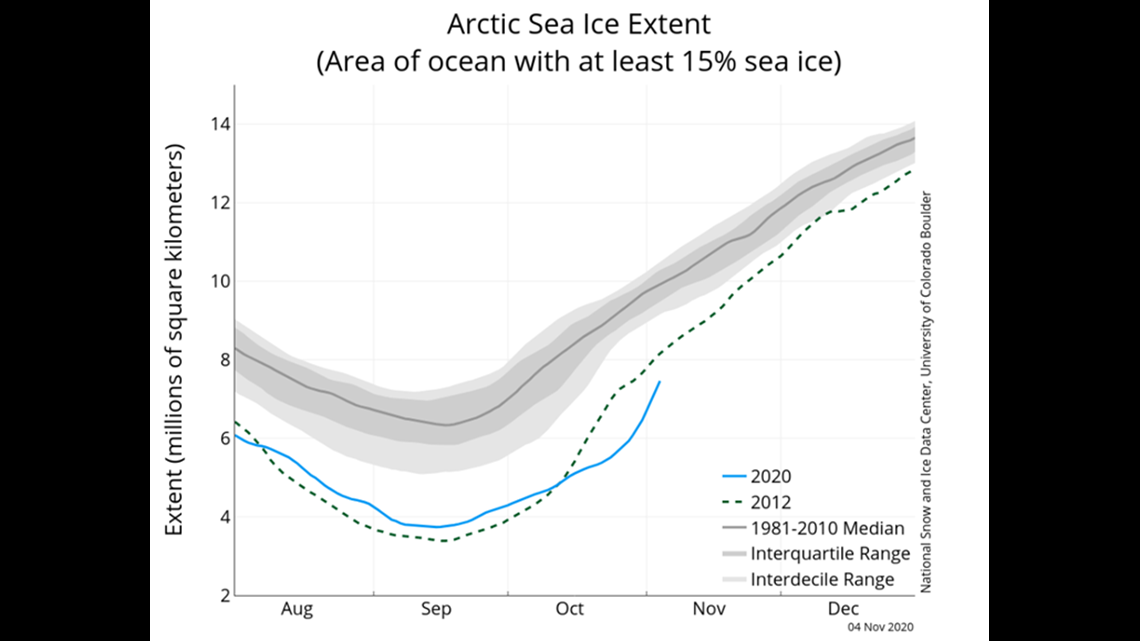
Record Low Arctic Sea Ice:
Low levels of Arctic Sea ice has a significant impact on the winter weather down here in the U.S. In particular, it affects the amount of cold air available but also the jet stream. Research has shown the lack of sea ice allows the jet stream to become much more amplified. Which means it tends to buckle north and south more abruptly at times. This can lead to quick, short-lived blasts of cold air and snow but it also tends to allow the Southeast ridge to setup for long periods of time over the Carolinas. The Southeast ridge is a warm pattern, more typical of summer and not winter, and in the past, has led to warm winters. The only thing you have to keep in mind is this can mean a warm and dry winter overall, but due to abrupt shifts in the jet stream, we can still get a short-term cold outbreak and wintry weather for short periods.

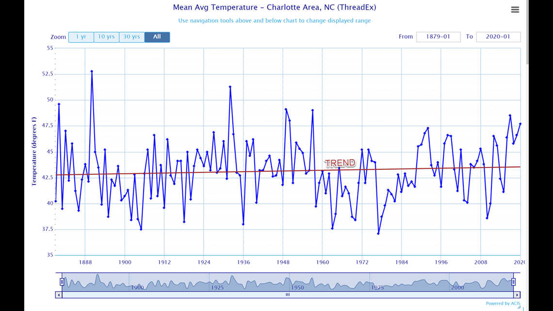
Climate Change:
As I showed above, the trend is pretty clear that we are seeing warmer and less snowy winters in the past 30 years. We still are going to get an occasional snowy winter, which seems to be more likely now due to a few big storms than an overall colder winter.

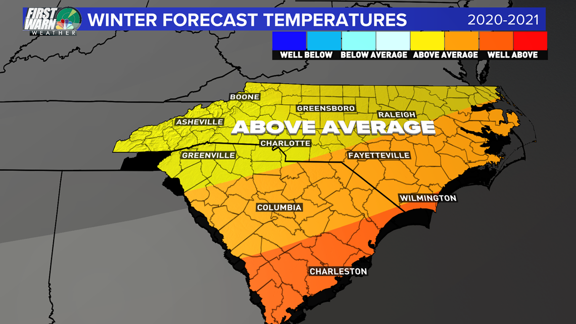
WINTER FORECAST 2020-2021:
TEMPERATURES: ABOVE AVERAGE
FORECAST CONFIDENCE LEVEL: HIGH
Let's cut to the chase; this winter, I expect it to be warmer than average due to all of the reasons stated above. La Nina, Low Arctic Sea Ice, Climate Change, and just the trend in the past 3 decades, and we haven’t had a below-average winter temperature-wise since 2014-15. With a La Nina, the chances of flipping that trend this winter seem very low.

SNOWFALL: BELOW AVERAGE
FORECAST CONFIDENCE MEDIUM
I struggled with this part of the forecast because it’s natural to think warm winter means less snow. Usually, that is the case, but often in these crazy jet stream winters, we can get a few big storms that can drive up the overall snowfall totals above the average of 4.3 inches despite a warm winter. Since the average is just 4.3 inches, one big storm late in the season could lead to an above average total when the other two-and-a-half months are warm and dry. So that's why I have some lower confidence in the snowfall forecast.


RAINFALL: SLIGHTLY ABOVE
FORECAST CONFIDENCE: MEDIUM
Naturally, I’d be inclined to go dry this winter, but just like we've gone with a warmer winter forecast due to the recent trends and patterns, I'm going to stick with the current trends of the past two years of above-average rainfall.
One thing we know is that it takes cold air and moisture to get winter storms, but often we get the moisture and not the cold air. With the cold air bottled up north, the subtropical jet stream could still brings lots of moisture to the Carolinas. Plus, the Gulf of Mexico and Atlantic Ocean are running very warm, meaning if we get the Southeast ridge, we could see higher moisture in the air, pushing more often into the region. So for that reason, I'm going with slightly above average rainfall this winter season.