
CHARLOTTE, N.C. — The sweltering summer heat and humidity have officially made it to the Carolinas and we're preparing for the hottest week of the year with "feels like" temperatures over 100 degrees this weekend.
But with all the heat comes the "ring of fire" — no, it has nothing to do with Johnny Cash — and the threat of strong-to-severe thunderstorms. WCNC Charlotte chief meteorologist Brad Panovich said we're looking at the potential for some really strong storms this weekend, too.
"The reason we call this the ring of fire is around these big rings of high pressure, we get these thunderstorms," Panovich said. "We're going to see these storms form up to our northwest in the Ohio Valley and kind of make a run down here into the western Carolinas."

"It's going to be really hot and humid here," Panovich said. "It could be sunny all day, not a cloud in the sky, then sometime in the late evening, these thunderstorm complexes move in and maybe even before morning. That's very common."
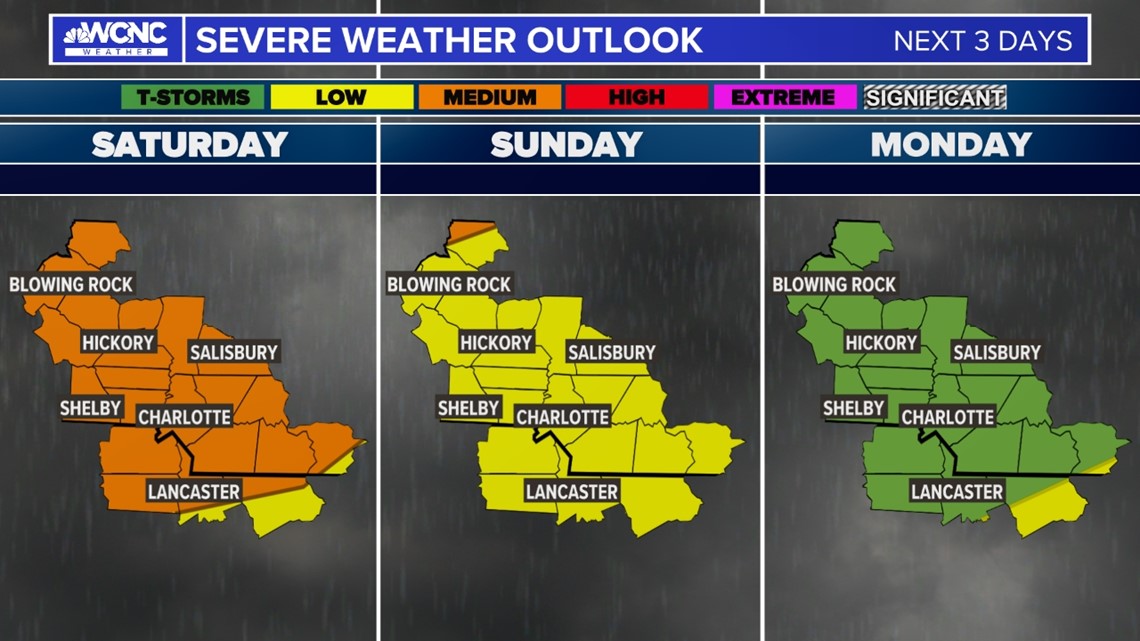
Saturday has a slightly higher risk for severe storms. Sometimes thunderstorms will cluster together and form a line of storms. This scenario is a possibility by Saturday afternoon and into the evening. This is why Saturday has a medium risk for areas along and northwest of Charlotte and low for everyone else.
"All in all, this is going to be one of those things where it's going to be tough to predict the exact timing of the storms," Panovich said. "But at some point in the setup, we're going to see some scattered big storms."
RELATED: How to stay cool in a heat wave
Why is it so hot?
Well, it's summer. But the scientific reason it's going to be so hot in the Charlotte area this week is something called a heat dome. The heat dome effect is when scorching heat combines with a dome of high pressure. It causes a steady increase in temperatures at the ground level due to warm air being trapped in the atmosphere.
Charlotte's forecast high temperatures through Monday will be in the low-to-mid 90s, but the heat dome will make it feel much warmer. Mulcahy's forecast calls for a heat index of 100 on Saturday, 106 on Sunday (which would prompt a 'heat advisory") and Monday will be the second hottest near the danger zone at 104.
5 ways to beat the heat
1. Wear the right clothes
Choose lightweight, light-colored clothes. Not wearing the right clothes could put you at risk of heat stroke.
2. Pace yourself
Limit your outdoor activity during extreme heat. Doctors recommend exercising early in the morning or later in the evening, when it's a little cooler.
3. Stay hydrated
Dr. Charles Bregier with Novant Health says water is better for you than a sports drink. It's important to drink water throughout the day and not just when you're outside.
4. Wear sunscreen
Getting sunburn can impact your body's ability to cool itself. Experts recommend wearing SPF 30 and reapplying if you're outside for a long time.
5. Know the signs
Experts say it's critical to know the signs of heat stroke. Those symptoms include throbbing headache, not sweating, red, hot and dry skin and a body temperature above 103 degrees. Other symptoms are a rapid pulse and a loss of consciousness.
If you experience any of these while outdoors, you should call 911 immediately.