
CHARLOTTE, N.C. — Vegetation and surfaces throughout the Carolinas have been coated in a sheet of ice Thursday as a winter storm impacts a large portion of North Carolina.
Winter Storm Warnings and Winter Weather Advisories are in effect for counties stretching from the mountains to the Triangle.
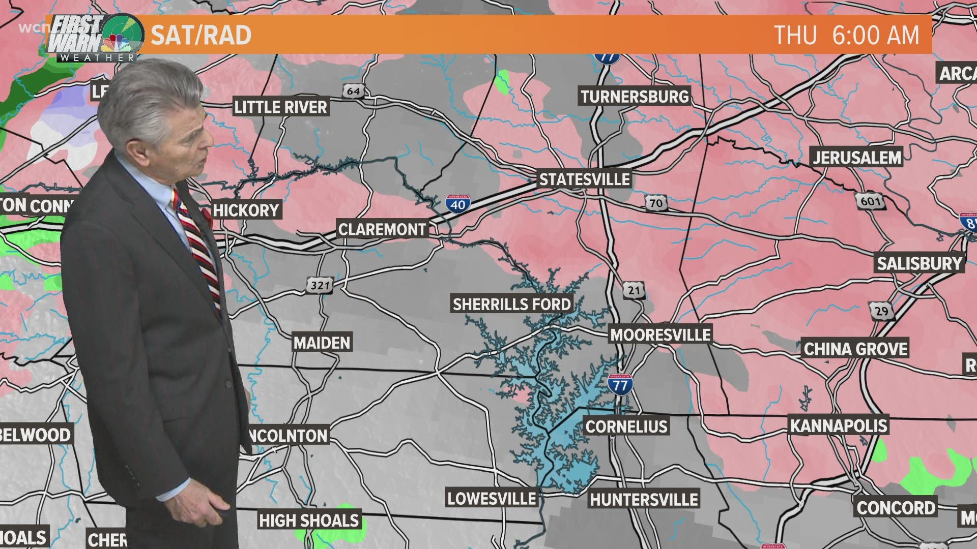
In Rowan County, WCNC Charlotte meteorologist Chris Mulcahy found upwards of 0.20" of ice.
Chief Meteorologist Brad Panovich says significant icing in areas north of Charlotte - along and near the Virginia border - could see prolonged power outages.
Duke Energy Wednesday said they are preparing for upwards of 1 million power outages in North Carolina related to the storm and they're urging customers to prepare for multi-day power outages.
Tim Buckley, the chief meteorologist at sister station WFMY News 2 in Greensboro, said in a tweet Thursday morning that the icing situation could quickly go from "fine" to "bad" quickly in the Triad.
By late morning, Union Grove and Salisbury were also reported 0.20" of ice. Harmony, Statesville, and Convor had 0.10". Amounts near 0.05" were reported in Hickory.
The most significant impacts are expected north and west of Charlotte, particularly along I-40. Dozens of trucks were on the roads Friday morning treating them for possible ice accumulation.
After the ice, the threat turns to flooding for portions of central, eastern, and coastal Carolinas. Flash Flood Watches extend westward as far as Lancaster County, South Carolina, and Anson County, North Carolina.
Portions of the South Carolina coast - south of Charleston and closest to Georgia - could even see some severe thunderstorms later Thursday.
What is the timing?
By 5 a.m., Mulcahy observed freezing rain along I-40 west of Statesville. Mulcahy said rain rates in the area were low at the time but all precipitation was freezing upon contact.
Panovich said the freezing rain and ice will last for several hours. By afternoon, temperatures are expected to get above freezing and precipitation will be more scattered with more cold rain and less ice.
"The only thing to watch out for, sometimes the cold air hangs on much longer than the guidance will indicate and that could keep the ice going into the afternoon," Panovich said. "I think everybody sees things improve by mid-to-late afternoon, and that's why the Winter Storm Warning goes through 7 p.m., we expect things to be moving out by then."
How much ice?
Panovich expects the biggest impacts to be along the I-40 corridor from Morganton to Greensboro, and areas north. This includes Alexander, Caldwell, Catawba, Iredell and Lincoln counties.
Panovich said those areas could see 0.3"-0.5". Areas just south of there, including Lake Norman, Mooresville, Davidson, Cornelius and Huntersville may see anywhere from a 0.2" to 0.4" of ice accumulation.
As you get further south into Charlotte, up to a tenth of an inch is possible, with a glaze expected to the South Carolina line. All cities north of I-85 are at risk of 0.1" to 0.2" of ice, Panovich explained.
Power Outages Likely
Duke Energy said they are preparing for over 1 million outages in North Carolina due to the storm. In a statement, Duke said customers should prepare for multi-day power outages.
Panovich predicts the most outages will be in the mountains and foothills, especially along I-40. Anyone who lives in the higher elevations in Ashe, Avery, Caldwell and Watauga counties will also be at risk for the major outages.
If you live in Charlotte, the chance of widespread power outages isn't that high right now. The greatest risk for widespread outages will be from the northern half of Mecklenburg County and north. Areas south of I-85, as well as Shelby, Gastonia and Concord, could see isolated outages.
RELATED: The winter mess west of Charlotte
Snow is not expected with this storm system.
"You do not need snow in order to be eligible for a Winter Storm Watch or Winter Weather Advisory," Panovich explained. "As Thursday approaches, the National Weather Service may decide to upgrade the Winter Storm Watch to a Winter Weather Advisory - or even an Ice Storm Warning or Winter Storm Warning."
"Temperature is a major factor in these situations," First Warn forecaster Larry Sprinkle said. "Even if the air temperature is above freezing at the surface, elevated areas could easily have temperatures at freezing or below. That's why bridges and overpasses can be dangerous, and why power lines and tree limbs can get a coating of ice."
Full list of ice reports in the Carolinas
County, Location, ST, Event Type, Mag., Remark, Report Time
ALEXANDER, TAYLORSVILLE, NC, FREEZING RAIN, 0.1, TRAINED SPOTTER REPORTED FREEZING RAIN AT CENTRAL ALEXANDER FIRE DEPARTMENT IN TAYLORSVILLE., 2021/02/18 08:10
ALLEGHANY, 1 W PINEY CREEK, NC, FREEZING RAIN, 0.15, 2021/02/18 07:15
ASHE, ASHLAND, NC, FREEZING RAIN, 0.13, 2021/02/18 07:30
ASHE, 2 NW WAGONER, NC, FREEZING RAIN, 0.1, 2021/02/18 07:00
ASHE, 1 N TODD, NC, FREEZING RAIN, 0.1, 2021/02/18 07:40
ASHE, 5 WSW SCOTTVILLE, NC, FREEZING RAIN, 0.1, 2021/02/18 08:30
ASHE, 1 E SHATLEY SPRINGS, NC, FREEZING RAIN, 0.05, 2021/02/18 07:27
AVERY, 3 ESE INGALLS, NC, FREEZING RAIN, 0.1, COCORAHS REPORTED FREEZING RAIN IN SOUTHERN AVERY COUNTY., 2021/02/18 07:00
BUNCOMBE, 5 E FAIRVIEW, NC, FREEZING RAIN, 0.2, COCORAHS REPORTED FREEZING RAIN IN SOUTHEASTERN BUNCOMBE COUNTY, 2021/02/18 07:00
BUNCOMBE, 5 SW LEICESTER, NC, FREEZING RAIN, 0.2, COCORAHS REPORTED FREEZING RAIN IN WESTERN BUNCOMBE COUNTY, 2021/02/18 07:00
BUNCOMBE, 1 ENE BLACK MOUNTAIN, NC, FREEZING RAIN, PUBLIC REPORTED FREEZING RAIN IN BLACK MOUNTAIN., 2021/02/18 08:03
CABARRUS, 2 SSE KANNAPOLIS, NC, FREEZING RAIN, PUBLIC REPORTED FREEZING RAIN IN NORTHERN CABARRUS COUNTY., 2021/02/18 07:00
CALDWELL, GRANITE FALLS, NC, FREEZING RAIN, TRAINED SPOTTER REPORTED FREEZING RAIN IN GRANITE FALLS., 2021/02/18 08:12
CASWELL, SEMORA, NC, FREEZING RAIN, 0.3, 2021/02/18 08:10
CASWELL, 4 NW UNION RIDGE, NC, FREEZING RAIN, 0.25, 2021/02/18 08:33
CATAWBA, 4 E MAIDEN, NC, FREEZING RAIN, 0.25, BROADCAST MEDIA REPORTED FREEZING RAIN IN BUFFALO SHOALS CATAWBA COUNTY., 2021/02/18 07:00
CATAWBA, 2 NE COOKSVILLE, NC, FREEZING RAIN, 0.1, BROADCAST MEDIA REPORTED FREEZING RAIN IN BANDY'S COMMUNITY CATAWBA COUNTY, 2021/02/18 07:00
CATAWBA, CONOVER, NC, FREEZING RAIN, 0.1, BROADCAST MEDIA REPORTED FREEZING RAIN IN CONOVER., 2021/02/18 07:58
CATAWBA, 1 WSW HICKORY, NC, FREEZING RAIN, 0.05, BROADCAST MEDIA REPORTED FREEZING RAIN IN HICKORY., 2021/02/18 08:19
DAVIDSON, WELCOME, NC, FREEZING RAIN, 0.11, 0.11 INCHES OF ICE ACCUMULATION ON TREES AND POWERLINES IN THE WELCOME AREA OF DAVIDSON COUNTY. NO ICE SPOTS SEEN ON ROADWAYS OR BRIDGES., 2021/02/18 08:20
DAVIE, 5 ESE HARMONY, NC, FREEZING RAIN, 0.1, ICE ACCUM ON ELEVATED SFCS, 2021/02/18 07:00
DURHAM, 4 N DURHAM, NC, FREEZING RAIN, 0.01, "SPOTTY ICE ACCUMULATION (GLAZE) ON ELEVATED SURFACES, RAINING MODERATELY AND 32 DEGREES.", 2021/02/18 04:30
FORSYTH, 2 N STANLEYVILLE, NC, FREEZING RAIN, 0.18, 2021/02/18 07:34
FORSYTH, KERNERSVILLE, NC, FREEZING RAIN, 0.09, 2021/02/18 07:15
FORSYTH, 3 NE WINSTON-SALEM, NC, FREEZING RAIN, 0.09, 0.09 INCHES OF ICE ACCUMULATION AS OF 7:00 AM AT THE SMITH REYNOLDS AIRPORT., 2021/02/18 07:55
FRANKLIN, 2 E PURNELL, NC, FREEZING RAIN, 0.06, 2021/02/18 06:30
GUILFORD, 5 ESE COLFAX, NC, FREEZING RAIN, 0.1, 0.1 INCHES OF ICE ACCUMULATION AS OF 7:00 AM FROM THE PIEDMONT TRIAD INTERNATIONAL AIRPORT., 2021/02/18 07:49
GUILFORD, 4 ENE GREENSBORO, NC, FREEZING RAIN, 0.01, CARS AND TREES BECOMING COATED WITH ICE., 2021/02/18 05:42
HAYWOOD, CLYDE, NC, FREEZING RAIN, 0.15, PUBLIC REPORTED FREEZING RAIN IN CLYDE., 2021/02/18 07:59
HENDERSON, 4 W FLAT ROCK, NC, FREEZING RAIN, 0.12, COCORAHS REPORTED FREEZING RAIN AT LAUREL PARK HENDERSON COUNTY, 2021/02/18 07:00
IREDELL, 4 SW HARMONY, NC, FREEZING RAIN, 0.12, 2021/02/18 07:00
IREDELL, 2 W STATESVILLE, NC, FREEZING RAIN, 0.1, PATCHY ICE ON ROADWAYS AND ELEVATED SFCS, 2021/02/18 08:04
IREDELL, MOORESVILLE, NC, FREEZING RAIN, 0, GLAZE FORMING ON TREE BRANCHES, 2021/02/18 07:55
JACKSON, 3 WNW BALSAM, NC, FREEZING RAIN, 0.1, PUBLIC REPORTED FREEZING RAIN IN NORTHWESTERN JACKSON COUNTY., 2021/02/18 07:00
MADISON, 1 WNW ALLENSTAND, NC, FREEZING RAIN, 0.25, COCORAHS REPORTED FREEZING RAIN IN ALLENSTAND, 2021/02/18 07:00
MADISON, 2 W CANTO, NC, FREEZING RAIN, 0.01, COCORAHS REPORTED FREEZING RAIN IN LEICESTER, 2021/02/18 07:00
MCDOWELL, 5 SSW OLD FORT, NC, FREEZING RAIN, 0.01, COCORAHS REPORTED FREEZING RAIN IN SOUTHEASTERN MCDOWELL COUNTY., 2021/02/18 07:00
MCDOWELL, 3 ESE BLACK MOUNTAIN, NC, FREEZING RAIN, 0, "COATING OF ICE ON VEGETATION, ELEV SFCS", 2021/02/18 07:00
MITCHELL, 2 SE BULADEAN, NC, FREEZING RAIN, 0.3, COCORAHS REPORTED FREEZING RAIN IN NORTHERN MITCHELL COUNTY, 2021/02/18 07:00
MITCHELL, 5 E CELO, NC, FREEZING RAIN, 0.2, COCORAHS REPORTED FREEZING RAIN IN SOUTHERN MITCHELL COUNTY, 2021/02/18 07:00
PERSON, 2 SSW CONCORD, NC, FREEZING RAIN, 0.13, 0.13 INCH MEASURED AT CONCORD CHURCH RD AND SEMORA RD., 2021/02/18 07:47
PERSON, 5 N BUSHY FORK, NC, FREEZING RAIN, 0.11, 0.11 INCH MEASURED AT MILL HILL RD AND TURKEY FEATHER DR., 2021/02/18 07:28
PERSON, ROXBORO, NC, FREEZING RAIN, 0.01, AT LEAST A GLAZE ON TREES AND OTHER ELEVATED SURFACES IN THE ROXBORO AREA VIA LOCAL NEWS BROADCAST., 2021/02/18 05:00
ROCKINGHAM, 1 NE MADISON, NC, FREEZING RAIN, 0.1, DRIVEWAY AND SIDEWALKS ALL GLAZED OVER., 2021/02/18 03:45
ROWAN, 1 E SALISBURY, NC, FREEZING RAIN, PUBLIC REPORTED FREEZING RAIN IN SALISBURY, 2021/02/18 08:01
STOKES, LAWSONVILLE, NC, FREEZING RAIN, 0.2, 2021/02/18 07:45
STOKES, 1 N LAWSONVILLE, NC, FREEZING RAIN, 0.2, 2021/02/18 08:03
SURRY, 2 NW TOAST, NC, FREEZING RAIN, 0.13, 2021/02/18 06:51
SURRY, LOW GAP, NC, FREEZING RAIN, 0.1, GLAZE STARTING. EVENT ONGOING., 2021/02/18 02:30
SWAIN, 2 ESE WESSER, NC, FREEZING RAIN, 0.01, COCORAHS REPORTED FREEZING RAIN IN WESSER., 2021/02/18 07:00
TRANSYLVANIA, 1 ESE CEDAR MOUNTAIN, NC, FREEZING RAIN, 0.2, "PUBLIC ESTIMATED 0.2"" OF FREEZING RAIN IN CEDAR MOUNTAIN.", 2021/02/18 07:00
WAKE, 1 NNW RDU INTERNATIONAL, NC, FREEZING RAIN, 0.04, 0.04 INCHES OF ICE ACCUMULATION AT THE RALEIGH DURHAM INTERNATIONAL AIRPORT AS OF 8:00 AM., 2021/02/18 08:33
WAKE, PURNELL, NC, FREEZING RAIN, 0.02, 0.02 INCH ICE ACCRUAL 5 MILES WEST OF YOUNGSVILLE., 2021/02/18 08:00
WAKE, PURNELL, NC, FREEZING RAIN, 0.02, 0.02 INCHES OF ICE ACCUMULATION AS OF 8:00 AM BY TRAINED SPOTTER., 2021/02/18 08:05
WAKE, 4 NE LAKE WHEELER, NC, FREEZING RAIN, 0.01, GLAZING OF ICE REPORTED ON THE TREES JUST SOUTH OF TRYON RD. ON LAKE WHEELER RD. ESTIMATE OF A TRACE OF ICE ACCUMULATION., 2021/02/18 07:20
WAKE, 5 N RALEIGH, NC, FREEZING RAIN, 0.01, A TRACE OF FREEZING RAIN NOTED ON MAILBOX AND ROOF RAILS ON VEHICLE. GLAZING APPEARS LIMITED., 2021/02/18 07:30
WAKE, 4 SSW RALEIGH, NC, FREEZING RAIN, 0.01, GLAZE OF ICE AT NWS RALEIGH ON THE TREES., 2021/02/18 08:08
WATAUGA, 2 SSE BOONE, NC, FREEZING RAIN, 0.2, FLAT ICE., 2021/02/18 08:15
WATAUGA, BOONE, NC, FREEZING RAIN, 0.1, GLAZE TO TENTH OF AN INCH OF ICE AROUND THE COUNTY. NO SLEET OR SNOW., 2021/02/18 05:15
WATAUGA, 1 ENE BOONE, NC, FREEZING RAIN, 0.1, 2021/02/18 07:00
WATAUGA, 4 SSE DEEP GAP, NC, FREEZING RAIN, 0.1, LIGHT FREEZING DRIZZLE AT TIME OF OBSERVATION., 2021/02/18 08:30
WATAUGA, 1 NNW BEECH MOUNTAIN, NC, FREEZING RAIN, 0.05, 2021/02/18 08:17
YADKIN, 2 ESE COURTNEY, NC, FREEZING RAIN, 0.25, 2021/02/18 07:50
YADKIN, 2 SE NEBO, NC, FREEZING RAIN, 0.1, FREEZING RAIN ON SERVICE AND ROADS ARE VERY SLICK., 2021/02/18 04:02
YANCEY, 2 WNW SWISS, NC, FREEZING RAIN, 0.25, PUBLIC REPORTED FREEZING RAIN IN WESTERN YANCEY COUNTY, 2021/02/18 07:00
YANCEY, BURNSVILLE, NC, FREEZING RAIN, 0.25, PUBLIC REPORTED FREEZING RAIN ON BURNSVILLE, 2021/02/18 07:55
YORK, FORT MILL, SC, FREEZING RAIN, 0.15, TRAINED SPOTTER REPORTED FREEZING RAIN IN FORT MILL, 2021/02/18 07:00