
CHARLOTTE, N.C. — For the second weekend in a row, we have had snow and sleet accumulations across the area. This time, the sleet and snow added up a little further east than usual. Huntersville, Charlotte, Concord, and Salisbury as just a few locations that had 0.1-0.5" of sleet and snow accumulations that are factored together.
This was all associated with a passing low-pressure system followed by a cold front. A lot of the snow and sleet that fell melted on contact and but it had a better time sticking for those who were in the Winter Storm Warning (Alexander, Ashe, Avery, Burke, Catawba, Caldwell, and Watauga County)
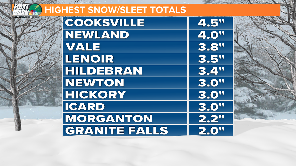
Here is a look at the highest snow/sleet totals reported to the National Weather Service:

SNOW TOTALS ACROSS THE CAROLINAS
BURKE, 1 W CONNELLY SPRINGS, NC, 2, PUBLIC, as of, 2021/02/07 00:08
BUNCOMBE, 2 WNW ASHEVILLE, NC, 2.5, PUBLIC, as of, 2021/02/07 00:09
BUNCOMBE, FAIRVIEW, NC, 2.2, PUBLIC, as of, 2021/02/07 00:09
HENDERSON, 3 WSW FLETCHER, NC, 2.8, OFFICIAL NWS OBS, ASHEVILLE REGIONAL AIRPORT, as of, 2021/02/07 00:09
CLEVELAND, KINGS MOUNTAIN, NC, 2, PUBLIC, as of, 2021/02/07 00:25
CHEROKEE, GAFFNEY, NC, 2, PUBLIC, as of, 2021/02/07 00:30
BURKE, 2 NE ICARD, NC, 3, BROADCAST MEDIA, as of, 2021/02/07 00:35
MCDOWELL, 4 WNW MARION, NC, 1.2, BROADCAST MEDIA, as of, 2021/02/07 00:35
GASTON, 2 S CRAMERTON, NC, 0.3, PUBLIC, LOCATION ESTIMATED, as of, 2021/02/07 00:40
RUTHERFORD, RUTHERFORDTON, NC, 2.5, PUBLIC, as of, 2021/02/07 00:46
RUTHERFORD, 6 SE DYSARTSVILLE, NC, 1, PUBLIC, GOLDEN VALLEY NEAR CANE CREEK MTN RD AREA., as of, 2021/02/07 00:48
GREENVILLE, GREENVILLE, NC, 1, PUBLIC, as of, 2021/02/07 00:50
MCDOWELL, OLD FORT, NC, 2, BROADCAST MEDIA, as of, 2021/02/07 00:50
BURKE, 5 S GLEN ALPINE, NC, 2, BROADCAST MEDIA, as of, 2021/02/07 00:58
BURKE, 3 NNE MORGANTON, NC, 2.2, BROADCAST MEDIA, as of, 2021/02/07 01:00
DAVIDSON, 3 ESE MIDWAY, NC, 1, PUBLIC, SOCIAL MEDIA REPORT ESTIMATED 1 INCH OF SNOW IN NORTHERN DAVIDSON COUNTY. MORE SNOW POSSIBLE., as of, 2021/02/07 01:00
MONTGOMERY, 1 NE MERRIMAC, NC, 0.5, OFFICIAL NWS OBS, OFFICIAL OBSERVATION AT NWS BLACKSBURG., as of, 2021/02/07 01:00
WILKES, 2 NE MAPLE SPRINGS, NC, 0.8, PUBLIC, as of, 2021/02/07 01:00
ROWAN, SALISBURY, NC, 0.5, PUBLIC, SNOW AND SLEET. WEST SIDE OF TOWN., as of, 2021/02/07 01:05
CATAWBA, 4 SSW LONGVIEW, NC, 3.4, AMATEUR RADIO, TRAINED SPOTTER, as of, 2021/02/07 01:08
CALDWELL, GRANITE FALLS, NC, 2, BROADCAST MEDIA, as of, 2021/02/07 01:10
CALDWELL, LENOIR, NC, 2, BROADCAST MEDIA, as of, 2021/02/07 01:10
BUNCOMBE, NNE SWANNANOA, NC, 2, COCORAHS, as of, 2021/02/07 01:15
CALDWELL, 5 SSW LENOIR, NC, 1.3, AMATEUR RADIO, TRAINED SPOTTER, as of, 2021/02/07 01:16
FORSYTH, KERNERSVILLE, NC, 0.2, PUBLIC, DUSTING OF SNOW AND SLEET., as of, 2021/02/07 01:30
DAVIDSON, 1 NNE LEXINGTON, NC, 0.5, PUBLIC, AROUND ONE HALF INCH OF SNOW AND SLEET ACCUMULATION BEFORE CHANGING TO RAIN., as of, 2021/02/07 01:40
BURKE, 4 NW COOKSVILLE, NC, 4, BROADCAST MEDIA, as of, 2021/02/07 01:51
WATAUGA, SEVEN DEVILS, NC, 1, PUBLIC, as of, 2021/02/07 02:09
HENDERSON, HENDERSONVILLE, NC, 4, PUBLIC, CALLER INDICATED IT COULD BE A LITTLE MORE THAN 4 INCHES, as of, 2021/02/07 02:16
CATAWBA, 4 NNE VALE, NC, 3.8, PUBLIC, as of, 2021/02/07 02:25
WILKES, WILBAR, NC, 2, PUBLIC, as of, 2021/02/07 02:38
CITY OF RADFORD, 1 ENE RADFORD, NC, 1.5, BROADCAST MEDIA, MEASURED AT THE RADFORD UNIVERSITY CAMPUS., as of, 2021/02/07 02:43
DAVIDSON, 1 NNE LEXINGTON, NC, 1, PUBLIC, SOCIAL MEDIA REPORT ESTIMATED AROUND 1 INCH IN THE LEXINGTON AREA., as of, 2021/02/07 03:02
SURRY, 4 NW PILOT MOUNTAIN, NC, 0.5, TRAINED SPOTTER, SNOW MIXED WITH RAIN., as of, 2021/02/07 03:49
BATH, 1 N MILLBORO, NC, 3, TRAINED SPOTTER, as of, 2021/02/07 04:09
CITY OF COVINGTON, COVINGTON CITY, NC, 1, PUBLIC, as of, 2021/02/07 04:38
CAMPBELL, 3 N EVINGTON, NC, 0.5, PUBLIC, as of, 2021/02/07 04:41
ALLEGHANY, 2 WNW IRON GATE, NC, 1.5, PUBLIC, as of, 2021/02/07 05:00
MONROE, 3 NNE WAITEVILLE, NC, 3.5, PUBLIC, MEASURED ON PETERS MOUNTAIN., as of, 2021/02/07 05:00
CRAIG, 2 SW SINKING CREEK, NC, 3.5, PUBLIC, as of, 2021/02/07 05:15
CITY OF COVINGTON, COVINGTON CITY, NC, 2, TRAINED SPOTTER, as of, 2021/02/07 05:26
BATH, 1 N MILLBORO, NC, 5, TRAINED SPOTTER, as of, 2021/02/07 05:35
MONTGOMERY, 1 SSW CHRISTIANSBURG, NC, 2.5, PUBLIC, as of, 2021/02/07 05:42
MONTGOMERY, 2 NE BLACKSBURG, NC, 3.8, NWS EMPLOYEE, as of, 2021/02/07 06:00
MONTGOMERY, 3 NNW BLACKSBURG, NC, 3.5, TRAINED SPOTTER, as of, 2021/02/07 06:00
CAMPBELL, 2 E LYNCHBURG AIRPORT, NC, 1.3, PUBLIC, as of, 2021/02/07 06:15
MONTGOMERY, 2 WNW CHRISTIANSBURG, NC, 2, NWS EMPLOYEE, as of, 2021/02/07 06:15
ALEXANDER, 2 N TAYLORSVILLE, NC, 0.8, PUBLIC, SNOW AND SLEET, as of, 2021/02/07 06:22
BURKE, 4 NW COOKSVILLE, NC, 4.5, BROADCAST MEDIA, as of, 2021/02/07 06:30
CATAWBA, 4 SW HICKORY, NC, 3, PUBLIC, MOUNTAIN VIEW COMMUNITY, as of, 2021/02/07 06:30
MERCER, 1 SE BLUEFIELD, SC, 3.5, PUBLIC, as of, 2021/02/07 06:30
WATAUGA, 2 NNW BOONE, SC, 2.6, PUBLIC, as of, 2021/02/07 06:30,