CHARLOTTE, N.C. — If you are planning to spend your Sunday outdoors in the Carolinas, you might want to reconsider your plans and stay Weather Aware.
A coastal low-pressure system, also known as a nor'easter, is going to develop on Saturday near Florida and move into the Carolinas by Sunday. The storm will bring strong winds, heavy rain, and dangerous surf conditions to the Carolinas. This will have similar impacts to that of a tropical storm. However, the storm is not officially named nor does it have the true scientific characteristics of a tropical storm.
The low-pressure system is expected to move inland over the Carolinas on Sunday, producing gusty winds of up to 50-60 mph along the coast and 30-40 mph inland. These winds could cause scattered power outages and tree damage, especially in areas where the soil is saturated from recent rainfall.
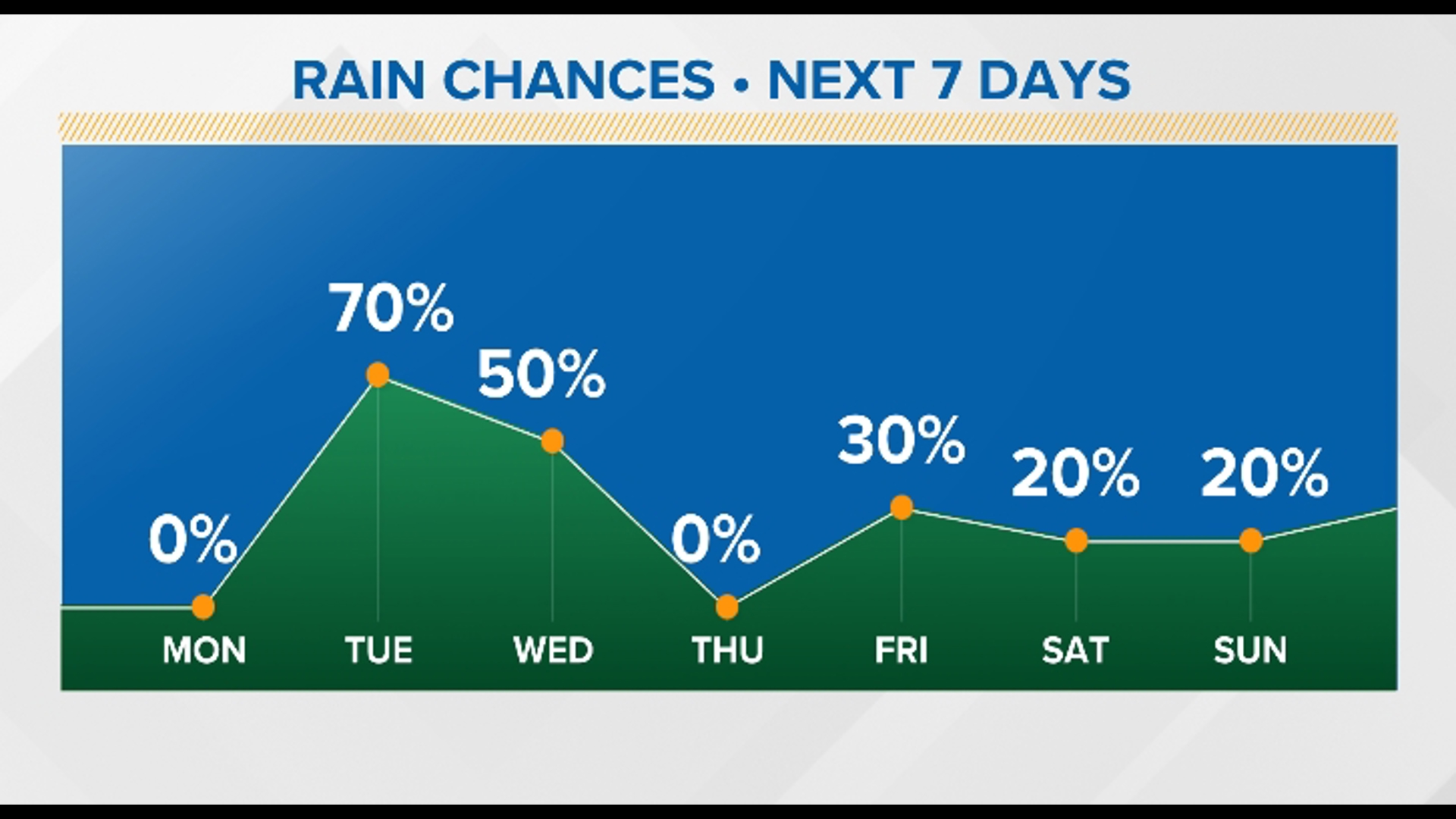
The low-pressure system will also bring widespread rain to the Carolinas, Virginia, and the Central Appalachians, with some areas receiving up to 2-4 inches of rainfall by Monday. The rain could cause some localized flooding, especially in low-lying areas and near rivers and streams. If you encounter flooded roads, turn around and don't drown.
"It's literally every single location," said Chief Meteorologist Brad Panovich on Saturday. "There's no start and stop time, there's no difference in one location or the other. The only difference is the amount of rain."
Sunday is deemed an "all-day" washout by Panovich, although the rain will start to taper off in the evening. In the Charlotte metro area, flash flood risks range from medium to moderate. Panovich notes there is also a risk for power outages, which he says is a twofold situation.
"One, because of the winds," he said. "But when you see this heavy rain for the first 12 hours of the day and later in the day the winds pick up. Anything that's in saturated soil, trees, will come down."

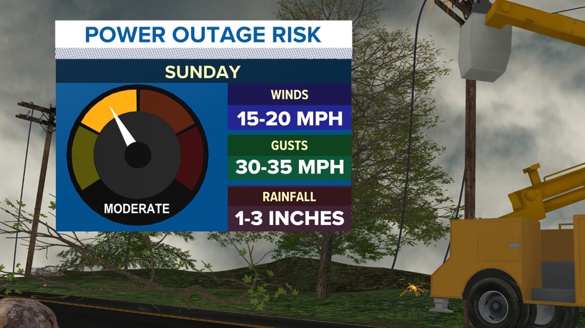
While it's difficult to predict exactly where outages are expected, Panovich notes there will be scattered outages throughout the day Sunday.
For the latest weather alerts, download the WCNC Charlotte mobile app and enable push notifications.
In addition to the wind and rain, the low-pressure system will generate dangerous surf and rip currents along the southeastern coast, from Florida to North Carolina. The waves could reach up to 8 feet in some locations, posing a hazard to boaters.
The coastal low-pressure system is not expected to develop into a tropical or subtropical storm, as it will remain connected to a front along the East Coast. However, it will still significantly impact the Carolinas and surrounding areas on Sunday. The pressure could be low enough to break records in a few locations like Charlotte. The system will gradually weaken and move up the east coast by Monday. It will remain windy Monday as northwest flow snow develops in the mountains where 2-4" of snow is possible.
RAISE YOUR WEATHER IQ: Nor'easters and how they get named
Contact Brad Panovich at bpanovich@wcnc.com or follow him on Facebook, X and Instagram.
WCNC Charlotte’s Weather IQ YouTube channel gives detailed explainers from the WCNC Charlotte meteorologists to help you learn and understand weather, climate and science. Watch previous stories where you can raise your Weather IQ in the YouTube playlist below and subscribe to get updated when new videos are uploaded.